
-
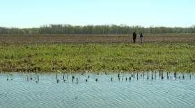 The White River has finally receded to below flood stage. For one research team at IU, the work to understand how 50-year floods affect Indiana’s terrain is just beginning.
 -
 The interim drainage committee came away with only an informal report Wednesday.
 -
 The Drainage Task Force is seeking to improve how landowners are notified and involved in mapping changes.
 -
 Indiana ranks in the middle of the Rural Capacity Index with 56 percent of communities below the national median. Plains states such as the Dakotas, Nebraska and Kansas sit in the bottom 10.
 -
 FEMA hasn't yet approved maps on Indiana's floodplain portal, but the Indiana Department of Natural Resources said it can be used for "general planning, construction and development purposes."
 -
 But the Indiana Department of Natural Resources warns, if it becomes law, the bill could jeopardize flood insurance in the county and possibly the state.

© 2026. The Trustees of Indiana University
Copyright Complaints
1229 East Seventh Street, Bloomington, Indiana 47405
Copyright Complaints
1229 East Seventh Street, Bloomington, Indiana 47405
News, Arts and Culture from WFIU Public Radio and WTIU Public Television
Play Live Radio
Next Up:
0:00
0:00
Available On Air Stations


