
-
 Sunday's winter storm rendered many roads impassable for standard vehicles. A team of local off-roaders took essential employees to work.
 -
 Justin Baker, deputy director of Monroe County Emergency Management, said the best way to weather the storm is to stay home.
 -
 The National Weather Service has compiled snow totals across the state from the Jan. 5-6 snow storm.
 -
 The Winter storm warning has been replaced with a winter weather advisory along and north of I-70 as the snow gradually tapers off.
 -
 Snowfall amounts are lighter than anticipated, but temperatures are in the single digits with wind chills dropping to -30 degrees.
 -
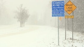
 Snowfall is expected to continue until 2 a.m. in Indianapolis, 10 p.m. in Terre Haute, 2 a.m. in Bloomington, and 5 a.m. in Seymour.
 -
 The line should reach Indianapolis and Terre Haute around 5 p.m. and Bloomington and Columbus around 9 p.m.
 -
 Indiana Governor Eric Holcomb hosted a briefing with agency heads from INDOT, ISP, and the Indiana Department of Homeland Security on the winter storm Wednesday.
 -
 The storm system will start as rain overnight Tuesday, then turn into a wintry mix of freezing rain, sleet and snow by Wednesday evening.
 -
 National Weather Service officials say the storm system will start as rain Tuesday night, then turn into a wintry mix of snow, sleet, and freezing rain by Thursday.

© 2026. The Trustees of Indiana University
Copyright Complaints
1229 East Seventh Street, Bloomington, Indiana 47405
Copyright Complaints
1229 East Seventh Street, Bloomington, Indiana 47405
News, Arts and Culture from WFIU Public Radio and WTIU Public Television
Play Live Radio
Next Up:
0:00
0:00
Available On Air Stations


