
-
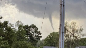 Damage reports are coming in after numerous tornado and thunderstorm warnings.
 -
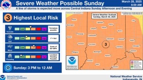
 Thunderstorms, possibly some severe and capable of producing tornadoes will be found across southwest central Indiana this evening.
 -
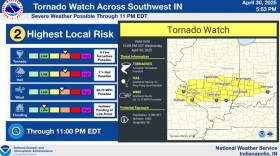
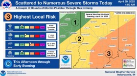 Scattered to numerous storms may be severe, with damaging winds as the main threat.
 -
 Up to 8 inches of rain fell over southern Indiana as flood warnings continue throughout the week.
 -
 National Weather Service officials say they’ll have more information once their survey is complete.
 -
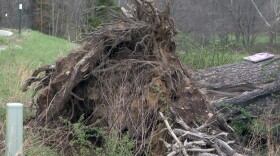
 Preliminary reports from the National Weather Service determined that most of the March 30 storm damage in Monroe, Brown and Bartholomew counties was caused by straight-line winds between 65 and 85 miles per hour.
 -
 Forecasters are calling for warmer conditions to continue over the weekend with showers and thunderstorms.
 -
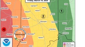 National Weather Service officials say a strong storm system is heading to the state in two waves.
 -
 Scattered to numerous snow showers will continue into the afternoon. Any additional snow accumulation will be less than an inch.
 -
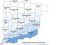 Up to 3 inches of snow with some ice mixed in is expected for portions of central Indiana Wednesday afternoon

© 2026. The Trustees of Indiana University
Copyright Complaints
1229 East Seventh Street, Bloomington, Indiana 47405
Copyright Complaints
1229 East Seventh Street, Bloomington, Indiana 47405
News, Arts and Culture from WFIU Public Radio and WTIU Public Television
Play Live Radio
Next Up:
0:00
0:00
Available On Air Stations


