
-
 The National Weather Service released new information based on field visits to areas that sustained damage in the storm, including the area in Greene County where a woman died Friday evening.
 -
 Storm damage in Indiana was reported in the east central city of Winchester, according to Indiana State Police, who said they were working to confirm fatalities.
 -
 The National Weather Service in Indianapolis says total ice accumulation of up to one tenth of an inch is possible throughout south-central Indiana.
 -
 Heat index values are expected to reach 105 degrees this week, according to the National Weather Service Indianapolis.
 -
 Storms could start as late as Tuesday night, but the better chance for severe weather will be Wednesday morning through the evening.
 -
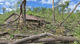
 An EF-3 tornado touched down in McCormick’s Creek State Park and continued northeast into Owen and Monroe counties at 11 p.m. Friday.
 -
 Tens of thousands of homes in central Indiana are without power after a deadly storm tore through the Midwest overnight. Authorities in western Indiana are reporting severe damage including gas leaks.
 -
 Monroe County’s tornado sirens will go off Tuesday at 10:15 am as part of a statewide tornado drill. The drill is part of the National Weather Service’s Indiana Severe Weather Preparedness Week.
 -
 The National Weather Service said police reported a tornado on the ground in Montgomery County at the intersection of Interstate 74 and State Route 25 north of Waynetown.
 -
 Weather service staffers who surveyed storm damage determined that an EF-2 tornado with a 26-mile-long path touched in the Wabash County town of Keensburg before sweeping across the south side of Mount Carmel.

© 2026. The Trustees of Indiana University
Copyright Complaints
1229 East Seventh Street, Bloomington, Indiana 47405
Copyright Complaints
1229 East Seventh Street, Bloomington, Indiana 47405
News, Arts and Culture from WFIU Public Radio and WTIU Public Television
Play Live Radio
Next Up:
0:00
0:00
Available On Air Stations


